Ɂehdzo Got’ı̨nę Gots’ę́ Nákedı
Sahtú Renewable Resources Board

Monitoring

  • 1995-ongoing Willow Lake Duck Banding

    Since 1995, the United States Fish and Wildlife Service (USFWS) has collaborated with the Tulita Renewable Resources Council (TRRC) and the Government of the Northwest Territories’ Department of Environment and Natural Resources (ENR) and more recently with the Sahtu Renewable Resources Board (SRRB) to band ducks within the Sahtu. The project was initially established at Loche Lake and Loche River northeast of Tulita in 1995 however, based on local traditional knowledge, in 1996 the banding station was moved to the nearby and larger Willow Lake where it has since remained. The station is operated by a waterfowl biologist from the USFWS, and two banding assistants hired from the Tulita Community.

    Picture 2

    The annual goal of the project is to band 2,000 mallards, 1,500 northern pintail, and all incidentally captured ducks (up to 1,000 per species) from 01 August – 01 September, which is the opening day of the duck-hunting season in the NWT and other Provinces.  

    It is critical that banded birds be reported.  You not only help continue this project and others like it, but the USFWS gains the data they need to monitor the health of duck and goose populations and set annual hunting regulations in the US and Canada.  Since inception the project has banded over 30,000 ducks at Willow Lake.

    Picture 6

    Please report band numbers to the National Bird Banding Laboratory in the US or Bird Banding Office in Canada (by calling 1-800-327-BAND, or on the web at: www.reportband.gov).  

    If you’re having trouble with the phone or website, you can also contact Team Member (below), Steve Olson, and he will report the band for you.

    Team Members

    Funder

    Wildlife Fund - Ɂehdzo Got’ı̨nę Gots’ę́ Nákedı

    Reports

      pdf Willow Lake Banding Report, 1995-2009 (18.57 MB)

      pdf Willow Lake Banding Report, 2011 (588 KB)

      pdf Willow Lake Banding Report, 2013 (395 KB)

      pdf Willow Lake Banding Report, 2014 (416 KB)

      pdf Willow Lake Banding Report, 2015 (3.74 MB)

      pdf Willow Lake Banding Report, 2016 (2.95 MB)

      pdf Willow Lake Banding Report, 2017 (3.26 MB)

      pdf Willow Lake Banding Report, 2018 (1.34 MB)

      pdf Willow Lake Banding Report, 2019 (4.05 MB)

    Total Budget

    $8,800

  • 2000-ongoing Arctic Salmon

    Pacific salmon are harvested in the Sahtú. These adult salmon are swimming up the Mackenzie River from the Arctic Ocean and are getting caught in subsistence nets set in late August to freeze-up in the Mackenzie River and also in Great Bear Lake. Although there is a historical record of Chum Salmon (also called dog salmon) harvest in the Sahtu, other species of salmon are now appearing, and the years when there are many salmon harvested are becoming more frequent.

    Due to these reports of changes to subsistence harvest patterns and the increase in Pacific salmon, Fisheries and Oceans Canada set up the Pacific Salmon Collection Program, which provides gift card rewards in exchange for subsistence harvested salmon. This program has been in place since 2000, and was expanded in 2011 to make it more convenient to trade in salmon. Many ENR offices, RRCs and the SRRB can now accept salmon and hand out gift card rewards.

    Karen Dunmall, an Arctic Fisheries Biologist at Fisheries and Oceans Canada, is collaborating with communities throughout the Canadian Arctic to study these salmon and identify what these changes in salmon abundance and distribution might indicate about the arctic ecosystem and how the presence of salmon may affect native fish species in the Mackenzie River and tributaries.  All salmon used for this research are obtained from the subsistence fisheries throughout the Canadian Arctic.

    For more information about the salmon research project in the Canadian Arctic, please visit www.arcticsalmon.ca or www.facebook.com/arcticsalmon. Karen posts on Facebook with progress updates, research findings, newspaper or radio interviews, where and when salmon are harvested in the Canadian Arctic, and what the research project is doing with the salmon that are traded in.

    Funding for this project is generously provided by Fisheries and Oceans Canada, the University of Manitoba, Government of Northwest Territories through the Northwest Territories Cumulative Impact Monitoring Program, Fisheries Joint Management Committee, Gwich’in Renewable Resources Board, Gwich’in Land Use Planning Board, the Sahtú Renewable Resources Board and a Liber Ero Postdoctoral Fellowship to Karen.

    Karen Dunmall

    Karen Dunmall with a chum salmon harvested in Great Bear Lake near Deline, NWT. This is the only live salmon Karen has touched in the Canadian Arctic because all of the salmon used for monitoring are provided from subsistence harvesters voluntarily trading in their fish to support this research.

    Photo Credit: Cody Dey

    Team Members

    Funders

    Wildlife fund - Ɂehdzo Got’ı̨nę Gots’ę́ Nákedı and University of Manitoba

    Total Budget

    $11,500

  • 2000-ongoing Great Bear Lake Fisheries

    The road to ecosystem redemption: Comparative study of degraded and pristine giant lakes of North America using Ecopath

    This project is focused on comparison of ecosystem health of pristine and degraded giant lakes of Canada and was partially funded by Aboriginal Affairs and Northern Development under NWT Cumulative Impact Monitoring Program (CIMP). Ecosystem health is comparatively a new approach in environmental management and refers to the condition and functioning of an ecosystem in comparison to the normal conditions and functions. The project also supports one of the objectives in the “Waterheart” Great Bear Lake Management Plan to develop an ecosystem model of the lake. This research is developing simple and robust ecosystem models that managers can use to explore the whole system management strategies for fisheries and to determine the risk of degradation of ecosystem health. The project also incorporates the traditional knowledge to deepen the understanding of cumulative impacts caused by the present and foreseeable future fishing and other anthropogenic activities and climate change. Under this project, a workshop was held in 2012 at Déline and traditional knowledge regarding temporal change in fish community, subsistence fisheries, climate change and community approach towards a healthy ecosystem was gathered through interviews and discussions during the workshop under proper partnership with the community. As hypothesized, the pristine GBL ecosystem looks more developed, stable and in better health as compared to few other great lakes of Canada. 

    Lake Trout in the Great Bear Lake

    Dr. Kimberly Howland and her research group has been conducting research on lake trout in Great Bear Lake on an annual basis since 2000. The emphasis has been on sampling lake trout among the different arms of the lake to better understand their size and age structure, growth, maturity and relative abundance for the purpose of assessing the status of harvested stocks. An additional component of the lake trout project has involved examining the presence of different forms of lake trout present in the lake and how they contribute to the biodiversity and functioning of the Great Bear Lake aquatic ecosystem. This is being accomplished through ongoing research that includes measuring different attributes of the shape of the trout from pictures taken in the field, gathering Traditional Ecological Knowledge of lake trout types through interviews with Délı̨nę community members, examining the diet and looking at the chemical properties of muscle tissue that provide us with an idea on long-term feeding habits, and looking at movements through archival tagging.

    The lake trout project was expanded in 2008 to include more comprehensive annual sampling for cisco in different depths.  Similar to the trout, the body shape of the cisco captured from shallow and deep habitats is being examined to determine if there are different forms of cisco as seen in many other deep north American lakes left behind after the last glaciation. The data collected so far has yielded a valuable time-series of information on the biology of lake trout in the lake and has confirmed the presence of multiple forms of lake trout and cisco that appear to have different ecological characteristics and roles in the Great Bear Lake food web.

     Although research on these key fish species is important, we recognize that they do not live in isolation, but are part of a larger ecosystem. We have begun to build on this species-specific research by expanding the scope of our research for the lake. In 2012 we initiated a multi-year ecosystem study which maintains the lake trout and cisco assessment research, but has greater spatial coverage of different habitats, and includes the whole fish community together with water quality, primary productivity and invertebrate production which are essential for supporting fish populations. This expansion of the research will improve our understanding of the lake and how fish productivity is maintained. The large lake monitoring protocols we have developed and the baseline data collected through this study will form an important basis for tracking and understanding the cumulative effects of climate change, fishing and other anthropogenic (human induced) drivers on the Great Bear Lake ecosystem and its fisheries.

    TheDélı̨nę Renewable Resources Council has been instrumental in coordinating hiring of technicians, renting of suitable boats for conducting the research, selection of suitable base camp locations, helping with logistics for remote camps, the collection of samples from community based monitoring sites, and dissemination of information about the research. 

    Team Members

    • Kimberly Howland, DFO
    • Délı̨nę Renewable Resources Council (DRRC)
    • Délı̨nę Lands and Finance Corporation
    • Natural Resources Délı̨nę
    • Field technicians who have participated in the project over the years (Jane Baptiste, Doug Baton, Isodore Betsidea, John Betsidea, Morris Betsidea, Moise Beyonnie, Gloria Gaudette, Bruce Kenny, Darren Kenny, Greg Kenny, Hughie Kenny, Jonas Kenny, Morris Lennie, George Menacho, Bobby Modeste, Morris Modeste, Nathan Modeste, Isreal Neyelle, Lyle Neyelle, Clyde Takazo, Lucy Ann Takazo, Allison Tatti, Gerald Tutcho, Archie Vital, Freddie Vital, Cameron Yukon, Cyre Yukon, Tyrone Yukon, Charity Yukon, Barbara Yukon, Chris Yukon)

    Funders

    Sahtú Renewable Resources Board, the Polar Continental Shelf Program, the NWT Cumulative Impacts monitoring Program, Canadian Circumpolar Institute, Natural Sciences and Engineering Research Council and Fisheries and Oceans Canada.

    Total Budget

     $25,000

  • 2012-2015 Water Health Monitoring

    Baseline understanding of the aquatic health in the area of heavy oil and gas exploration in the Sahtu 

    In 2012, the Cumulative Impact Monitoring Program (CIMP) with various academic, government and community partners, including the Sahtu Renewable Resources Board, proposed a five year project to study the aquatic health in the area where intensive oil and gas exploration is taking place.  Although there are many proposed and active developments west of the Mackenzie River, between Tulita and Norman Wells, there currently is very little information on the health of aquatic systems in the area.

    A baseline water quality and stream health assessment program was designed with input from academics, communities (Tulita and Norman Wells) and regulators (SLWB).  Undisturbed and disturbed streams (i.e., streams located downstream from winter roads, all weather roads, well pads, seismic lines, camps, quarries, drilling activities) are being sampled for water quality as well as benthic macroinvertebrate abundance and diversity to determine baseline conditions throughout the watersheds and streams of key interest.  

    Team Members

    • Krista Chin
    • Norman Wells Renewable Resouces Council
    • Tulita Renewable Resources Council

    Funder

    Cumulative Impact Monitoring Program (CIMP, NWT) 

    Total Budget

    $29,700

  • 2013-ongoing Sahtú Mercury Research Synthesis

    The long-range atmospheric transport of mercury and subsequent deposition in Arctic environments is an ongoing global concern. In November 2013, after years of negotiations, a legally binding international treaty, the Minamata Accord, to reduce harmful emissions of mercury was signed by more than 140 nations.

    In the NWT, and in particular in the Sahtú Region, community concern about the potential negative impacts of mercury contamination in fish, public health advisories for local lakes (e.g., Kelly Lake), and associated human health risks remains a priority. As a result, the proposed research will help Sahtú communities to better understand the relevance and findings of mercury studies that have been undertaken. The need for a compilation, analysis and synthesis of research on mercury in the Sahtú, and reporting back to front-line workers and community representatives, became apparent at the Tulı́t’a Research Results Workshop in November 2013, when numerous concerns were raised.

    The proposed project will accomplish the following: 1) desktop review and synthesis of mercury research data for the Sahtú region, 2) compare research findings with guidelines and advisories to determine where concerns may exist, and 3) summarise findings of Sahtú mercury research and identify any gaps (research and communications).

    Working through the ɁehdzoGot’ı̨nę Gots’ę́ Nákedı and the Sahtú Environmental Research and Monitoring Working Group, the proposed research project will emphasize the synthesis of existing data for the priority contaminant mercury. The work will be a desktop study, with guidance and feedback provided by the Sahtú Environmental Research and Monitoring Working Group. Work will be carried out between July and October 2014, with reporting and a community summary of findings to be prepared by mid-December 2014.

    Funders

    Northern Contaminants Program, AANDC

    Funding 

    $15,000

  • 2014-2015 Elders Gathering

    The purpose of this gathering was to engage in dialogue with elders about wildlife management, research and monitoring.

    Team Members

    Jeff Walker, ENR

    Michael Neyelle, Ɂehdzo Got’ı̨nę Gots’ę́ Nákedı

    Funder

    Environment and Natural Resources, GNWT

    Total Budget

    $ 5,830

  • 2014-2016 Monitoring Framework

    This project will involve literature review and collaborative research with RRCs and industry. The Guidelines will be developed to complement existing BEAHR  (Building Environmental Aboriginal Human Resources) Occupational Standards and course curriculum for training monitors, as well as the NWT Experiential Science curriculum for high schools, and the NWT Cumulative Impact Monitoring Program’s Pathways guide for community-based research. The intended audience will be RRCs and community members, high school students, adult education students, as well as industry and researchers. This project is prioritized for timely completion so that it can be applied in the context of monitoring for the 2014-2015 winter exploration season in the shale oil play.

    The Framework will be structured as a plain language strategic planning document. The structure of the document will be adapted based on inputs from various stakeholders, but may include sections on the following topics:

    • What is environmental monitoring?
    • Why is environmental monitoring important in the Sahtú Region?
    • What are the priority questions that monitoring can address?
    • How can monitoring make a difference in decision-making?
    • How do harvesters monitor the land, water, and wildlife?
    • How do scientists monitor the land, water, and wildlife?
    • What skills and knowledge are needed to do monitoring that addresses priority questions?
    • What are the obstacles to getting the skilled community monitors that we need in the Sahtú Region?
    • What can be done to build a team of professional monitors?
    • How can the team be supported over the long term?

    Team Members

    • Shelagh Montgomery
    • Deborah Simmons, Ɂehdzo Got’ı̨nę Gots’ę́ Nákedı
    • Joe Hanlon, Ɂehdzo Got’ı̨nę Gots’ę́ Nákedı

    Funders

    Wildlife Fund - Ɂehdzo Got’ı̨nę Gots’ę́ Nákedı, AANDC (Aboriginal Affairs and Nothern Development Canada)

    Total Budget

    $71,632

  • 2014-2021 Winter Track Surveys

    Communities, government and industry have all expressed interest in monitoring the cumulative impacts of oil and gas exploration activity and other natural factors on wildlife within the Sahtú region. The Cumulative Impacts Monitoring Program (CIMP) has provided funding to start a collaborative wildlife monitoring program entitled "Multi-species monitoring using winter wildlife track surveys in the Sahtú Settlement Region" that uses surveys of wildlife tracks in the snow to measure changes in abundance and distribution of species such as boreal woodland caribou, moose, wolves and other furbearers such as marten and lynx. Further funding was secured from the NWT Environmental Studies Research Fund to continue the program from 2017-2021. The territorial government, Sahtú Renewable Resources Board (Ɂehdzo Got'ı̨nę Gots'ę́ Nákedı), and Tulı́t’a and Norman Wells Renewable Resource Councils (Tulı́t'a Ɂehdzo Got'ı̨nę and Tłegǫ́hłı Renewable Resources Council) have been partners on this project.  Explor also provided track survey data collected during their Tulita seismic survey program in 2012 and 2013.  Track surveys are conducted by teams of youth and elders along trails and seismic lines around each community.  A mobile data collection app (Trailmark) is used to record tracks on handheld computers using a series of standard questions, along with coordinates, photos and audio recordings associated with each track. 

    WinterTrackMonitoring

    Photo: William Horassi recording a Mink track along the trail to Willow Lake (Credit: GNWT-ENR)

    This project will provide maps of where wildlife tracks are seen on the land, and information describing the habitat at each track observation. By repeating the surveys along the same trails and seismic lines over many years we will measure whether wildlife abundance and distribution is changing and if there is a link to the amount of industrial activity, forest fires and other human activity in different areas. This will help wildlife and land managers to understand the combined impacts of industrial development and natural disturbances and help to guide decisions about land use and wildlife harvesting.

    Team Members

    Funders

    Reports

    NWT Environmental Research Bulletin:

    http://sdw.enr.gov.nt.ca/nwtdp_upload/128-CIMP_Bulletin_v3i15_press.pdf

    Final Project report for CIMP:

     http://sdw.enr.gov.nt.ca/nwtdp_upload/2016-17%20FINAL%20REPORT%20-%20CIMP162%20(Hodson)%20-%20Sahtú%20Snow%20Track%20Monitoring_26May2017%20(3).docx

    2017-2018 ESRF Annual Report                                                                                                       

    https://www.nwt-esrf.org/sites/default/files/2018-08/2017%202018%20ESRF%20Annual%20Report.pdf

    Other reports and presentations:

    Search for “CIMP162” on the NWT Discovery Portal http://nwtdiscoveryportal.enr.gov.nt.ca/geoportal/catalog/main/home.page

    Total Budget

    ~$75,000 / yr


  • 2015 Literature Review and Interviews: Indigenous Ways of Knowing Boreal Caribou Populations

    This project was conducted for the Department of Environment and Natural Resources (ENR) of the Government of the Northwest Territories and the Ɂehdzo Got’ı̨nę Gots’ę́ Nákedı (Sahtú Renewable Resources Board, SRRB). It included a literature review and a series of interviews with experienced researchers and knowledge holders about Indigenous ways of knowing and monitoring boreal caribou.  Boreal caribou are listed as threatened in Canada and the Northwest Territories (NWT), and wildlife management organizations in the NWT are mandated to monitor population abundance and trends in order to make management planning decisions.

     Boreal caribou are an important animal for First Nations and Métis communities in almost all regions of the NWT.  Hunters and Elders have comprehensive Traditional Knowledge about past and current caribou populations, movements, health, habitat, and other topics.  In many Indigenous societies, this type of information is traditionally used in adaptive management processes.  Therefore Traditional, community, and Indigenous Knowledge can be of value for determining wildlife population abundance and trends, among many other topics, and a range of monitoring programs accommodate Indigenous Peoples or methods to some degree. 

    The resulting report reviews approaches to understanding and developing Indigenous Knowledge and ways of knowing about wildlife populations that could have potential as monitoring methods for boreal caribou populations.  It details theoretical and methodological considerations for ENR, who plan on initiating a monitoring program for boreal caribou with NWT communities, and includes a discussion of limitations and challenges.  Several northern case studies are presented as examples of monitoring projects that are already underway, and a suite of eight potential monitoring measures or ‘indicators’ are introduced, including a consideration of their possible applicability for boreal caribou. While there is an emphasis on Traditional Knowledge systems of the north, literature and models for working with Indigenous ways of knowing from other parts of the world are also included in this review and report where relevant.

    This report builds on the existing literature by proposing methods to develop a monitoring program for boreal caribou population abundance and trends in the NWT.  The authors recommend that ENR initiate a collaborative and iterative approach to develop regionally and culturally-appropriate monitoring approaches with interested communities across the NWT.  

    The ideas presented in this report formed the basis for further work being done to develop a national monitoring strategy for boreal woodland caribou that would be inclusive of Indigenous ways of knowing.  The National Boreal Caribou Knowledge Consortium (NBCKC) is a forum for knowledge sharing, generation, and mobilization. Members of the NBCKC represent provincial and territorial governments, Wildlife Management Boards, Indigenous Peoples and communities, industry, environmental non-governmental organizations, and academic researchers.  Several representatives who are part of the NBCKC are also members of a parallel body known as the Indigenous Knowledge Circle (IKC). The IKC advocates for the respectful inclusion of Indigenous Knowledge, supports the transition towards Indigenous-led management to support the recovery of caribou, and, provides opportunities for learning about what is working and not working in Indigenous contexts.  In 2020 the IKC focused their efforts on further developing some of the ideas presented in the 2015 Indigenous Ways of Knowing Boreal Caribou Populations report and initiated the construction of a database of Indigenous-led caribou projects across Canada as one of a series of ‘tools’ to be added to a national ‘Caribou Monitoring Toolbox’. More on the work of the NBCKC and the IKC can be found at: https://www.cclmportal.ca/organization/national-boreal-caribou-knowledge-consortium.

    Team Members

    Funders

    Department of Environment and Natural Resources (ENR) of the Government of the Northwest Territories

    Report

      pdf Literature Review and Interviews: Indigenous Ways of Knowing Boreal Caribou Populations (1.12 MB)

  • 2016-2019 Fish Monitoring - Environmental DNA

    Environmental DNA, or eDNA, is the DNA of the things that live in the environment. Through this project, we are developing eDNA as a tool to assess the presence of specific fish species without actually seeing the fish themselves. While eDNA techniques have obvious applications to fisheries management and conservation issues, including assessing current and potentially shifting distributions and habitat use in the vast and rapidly changing Arctic, protocols specific to northern environments remain to be developed and validated against traditional sampling methods in remote locations. Therefore, for this project, we are focused specifically on developing protocols to detect rare and cryptic species in remote northern watersheds using a community-based monitoring approach. We are looking specifically for the DNA from Dolly Varden, bull trout, pink salmon and chum salmon in smaller rivers in the Gwich’in Settlement Area, and in the Mackenzie River in the GSH and Sahtú.

    eDNA sampling Mountain 1

    eDNA Fish

    Team Members

    • Karen Dunmall, Fisheries and Oceans Canada
    • Robert Bajno, Fisheries and Oceans Canada

    Partners

    • Gwich'inRenewable Resources Board
    • Nę K’ǝ Dene Ts’ı̨lı̨ Forum

    Funders

    Cumulative Impact Monitoring Program (CIMP)

  • 2017-2020 Sahtú Environmental Management Decision-Support Project

    The Sahtú Renewable Resources Board has partnered with ALCES to look at what the future Sahtu landscape may look like based on different scenarios of natural and human-driven change. The project is funded by NWT CIMP with in-kind contributions from ALCES and the SRRB.

    ALCES models future changes based on known environment and landscape cover, an understanding of historic changes, and projected indicators of change to the environment, human footprint and landscape.

    The project provides a forum to look at potential future outcomes of environmental changes to support decision-making in the Sahtu. Partnered with the Sahtu Environmental Research and Monitoring Forum, community members are helping define future scenarios of landscape change. These scenarios are then used to project simulations over the next 50 years. Simulations are being developed for climate and fire, population and settlements, energy and mining development, woodland caribou range disturbance and mountain caribou population dynamics.

    Models

    Sahtu Landscape Futures

    Sahtu Landscape Disturbance

    Woodland CaribouSahtu Permafrost and Climate Change

    Sahtu Temperature Change

    Sahtu Permafrost Change

    Sahtu Fire and Forest Change

    Sahtu Land Use Change

    Woodland Caribou Range Change

    Sahtu Infrastructure Risk

       pdf Sahtú Environmental Model (875 KB)

    Project Team

    Funders

    • NWT Cumulative Impact Monitoring Program
    • ALCES

    Budget

    $180,000


  • 2017-2022 Tracking Changes

    Tracking Change… is a new research initiative funded by the Social Sciences Humanities Research Council of Canada and led by the University of Alberta, the Traditional Knowledge Steering Committee of the Mackenzie River Basin Board, the Government of the Northwest Territories and many other valued partner organizations. Over six years (2015-2022), the project will fund local and traditional knowledge research activities in the Mackenzie River basin and sister projects in the Lower Amazon and Lower Mekong River Basins, with the long term goal of strengthening the voices of subsistence fishers and Indigenous communities in the governance of major fresh water ecosystems. The project developed in recognition that river systems are important social, economic, cultural and ecological places that contribute to the well-being of communities in diverse ways. River peoples, particularly Indigenous peoples who have well developed fishing livelihoods can offer extremely valuable insights about long term (historic and current) patterns of social and ecological change and the interconnections between the health and dynamics of these river systems and that of river communities. Although based on oral traditions, this system of observation or “tracking change” is much like monitoring.   Like those who live on Canada’s east and west coasts, the ability of Indigenous communities in the Mackenzie River Basin to maintain fishing as a livelihood practice is of social, economic and cultural importance to all of Canada; if this river system is not healthy, how can we be?

    tracking images

    Fishers have been tracking change in the same places, in the same ways, using the same signs & signals for many generations. Such traditional knowledge is key to our understanding of many kinds of issues resulting from resource development, climate change and other land uses. This tracking of change is not simply a technical process; people watch, listen, learn and communicate about change because they care about the health of the land and the health of their communities.

    tracking images 2

    For more information on the project, please visit http://www.trackingchange.ca/

    Team Members

    Funder

    Social Sciences and Humanities Research Council, led by the University of Alberta, the Mackenzie River Basin Board, and the Government of the Northwest Territories in collaboration with many other valued Aboriginal organization partners and universities.

    Reports

      pdf Literature Review – Local and Traditional Knowledge in the Great Bear Lake Watershed, December 2016. (4.01 MB)

      pdf Tracking Change Report 2017 (66.73 MB)

      pdf The importance of traditional knowledge for maintaining fishing livelihoods during times of change in the Sahtú Region, 2018. [Newsletter] (1.13 MB)

  • 2020-2024 FISHES

    Fishes Logo


    FISHES: Fostering Indigenous Small‐scale fisheries for Health, Economy, and food Security

    Genome Canada Large-Scale Applied Research Project Competition: Genomics and Feeding the Future (2020-2024)

    How can knowledge-co-evolution processes inform inclusive fisheries co-management and enhance food security, conservation, and socio-economic development in northern Indigenous community settings? Sahtú (Great Bear Lake) plays a vital role in the local culture, food security, and economy of the Dene community of Délı̨nę and the broader Sahtú Region. The subsistence fishery from this relatively pristine Arctic lake is a dietary staple in Délı̨nę and is essential for the community's cultural and spiritual connection to the land and water. Long-term monitoring by Fisheries and Oceans Canada provides valuable stock data from the past 20 years. The Genome Canada FISHES project in Sahtú is bringing together Délı̨nę Got'ı̨nę knowledge holders and scientists to progress both Dene naowerǝ́ (knowledge) and science in support of knowledge co-evolution as a basis for planning in the context of environmental change. Knowledge interpretation and validation with the Délı̨nę Ɂekwę́ hé Łúé hé (Caribou and Fish) Working Group will ensure the project remains locally relevant and culturally appropriate.

    The FISHES project in Délı̨nę is part of a nation-wide project to develop and apply genomic approaches in concert with Indigenous knowledge to address critical challenges and opportunities related to food security and commercial, recreational and subsistence fisheries of northern Indigenous Peoples in Canada (Inuit, Cree and Dené communities). The project will develop genomic resources for six species important to northern communities and use these resources to identify genetically distinct populations, assess their vulnerability to future climatic conditions, quantify their contributions to mixed‐population harvests, and measure the contribution of fish from developing hatchery programs to subsistence harvests. FISHES will support the co‐generation of knowledge to foster the development and co‐management of sustainable fisheries and will also contribute to our ability to forecast the response of key fisheries to rapid global and socio‐economic changes in northern Indigenous communities.

    Learn more at the project website.

    FISHES Project Feature in IAGLR’s 64th Conference on Great Lakes Research

    The FISHES project was featured in the International Association for Great Lakes Research (IAGLR) 64th Conference on Great Lakes Research (May 17-21, 2021). Délı̨nę community research partner and Elder’s Council representative, Walter Bezha, co-presented with Grace Martin on the FISHES project in Sahtú as part of the session on bridging knowledge systems between Indigenous and non-Indigenous communities.

    The theme of the conference this year was “Bridging: Knowledges • Seven Generations • Land to Lake“. “This theme evokes our goal of connection. Today we see an urgent need for people to connect across divides of race, culture, and political viewpoint, as well as across scientific disciplines and levels of scientific literacy.”

    See the IAGLR conference presentation here.

    FISHES Team Members

    Past Team Members

    FISHES Délı̨nę Team1


  • Bat Monitoring and Education

    This project involves confirming observations of bats in the area of Norman Wells by using a bat sensor, and educational activities to enhance awareness of bats as a species scheduled for forthcoming assessment under the Species At Risk Act.  A bat booklet and final report will be produced.  The final report and data will be made available for the forthcoming bat assessments to be completed in 2016.  Bats were recently found in this area, previously unknown to scientists as bat habitat.

    Team Members

    Funder

    Government of the Northwest Territories - Species At Risk

    Total Budget

    $5,000

  • Bosworth Creek

    Between 2007 and 2010, a monitoring project of Bosworth Creek was sponsored by the Ɂehdzo Got’ı̨nę Gotsę́ Nákedı, with funding from the NWT Cumulative Impact Monitoring Program (CIMP) along with other partners. As part of this project, students at Mackenzie Mountain School were engaged to monitor aquatic ecosystem health. Sampling and analysis of bird populations, soil and water chemistry, fisheries, fish habitat, benthic invertebrates, amphibians, and creek habitat were conducted. Community monitors and researchers were trained, and Mackenzie Mountain School students learned a wide range of scientific applications. The Ɂehdzo Got’ı̨nę Gotsę́ Nákedı developed capacity to monitor impacts and account for natural and man-made changes to watersheds. This information was considered in the Mackenzie Gas Project cumulative effects hearings.

    bosworth

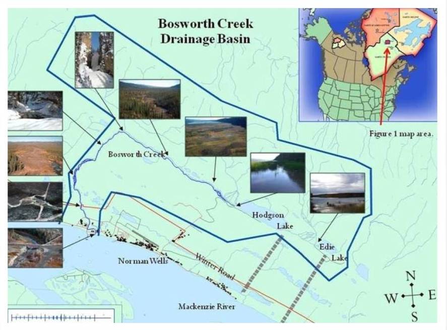
    Bosworth Creek originates at Hodgson (Jackfish) Lake (65° 18’N 126 41’W), Tulita District, Sahtu Settlement Area and parallels the base of Discovery Ridge before changing course and joining the Mackenzie River within the municipal boundaries of the Town of Norman Wells. The creek exhibits a variety of habitats along its course and has played an important role in local history. Natural flow was impeded with the construction of a weir in 1960 approximately 250 metres from its convergence with the Mackenzie River. The pond created behind this weir supplied both the oil refinery for their steam plant and the Town of Norman Wells with drinking water. The town abandoned this water source in 1991 and closure of the refinery in 1996 prompted channel flow reclamation as recommended by the Government of the Northwest Territories (GNWT). The weir was removed and natural flow restored in 2005 under Imperial Oil Resources NWT Limited’s (IORL) Reclamation and Restoration Plan.

    bosworth2

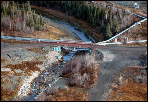
    The weir site at the lower Bosworth Creek bridge within the IORL lease property

    bosworth3

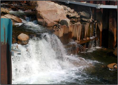
    The weir site at the lower Bosworth Creekbridge between 1960 – 2005

    bosworth4

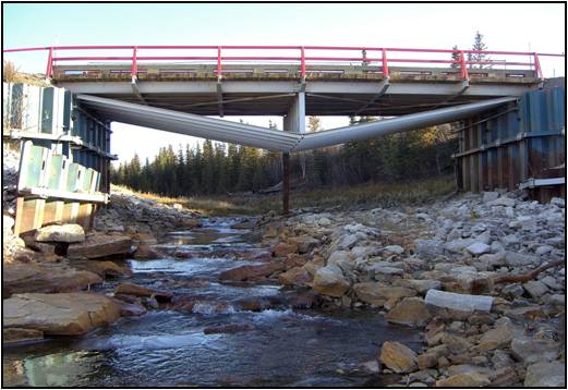
    The current site following removal of the weir in 2005

    The Bosworth Creek Monitoring Project was developed following questions raised by local residents regarding the absence of whitefish and other aquatic species. The general question was “Now that the barrier has been removed, will these animals re-inhabit the stream on their own or should they be re-introduced?” The SahtuRenewable Resources Board (SRRB) contacted the Department of Fisheries and Oceans (DFO) and discussed possible avenues of mitigation. It was concluded that re-stocking the creek was unnecessary due to the weir’s removal and that natural introductions should occur following stream reorganization.

    The recent restoration of Bosworth Creek presents a unique opportunity for local youth and residents to monitor aquatic ecosystem health. This monitoring project enables students and others to learn about local fish, invertebrates, hydrodynamics, sedimentology, streambed morphology, sampling techniques, data collection and evaluation. Students from Mackenzie Mountain School learn a wide range of scientific applications and report their findings to the scientific community through public presentations, science fair projects and publications. 

    Project Summaries:

    pdf Bosworth Creek Ice Study: Implications for the Northern Ecosystems (2.33 MB)

    pdf Bosworth Creek Ice Study: Implications for the Northern Ecosystems Poster (1005 KB)

    pdf Bosworth Creek: Literature Review (255 KB)

    pdf Bosworth Creek: Water Quality Data (2.80 MB)

    pdf Bosworth Creek History Project (2.94 MB)

    pdf 2006-2007 Bosworth Creek Monitoring Project (2.40 MB)

    pdf 2007-2008 Bosworth Creek Monitoring Project (1.13 MB)

    pdf  2008-2009 Bosworth Creek Monitoring Project (40 KB)

    pdf 2009-2010 Bosworth Creek Monitoring Project (45 KB)

  • Cumulative Effects Workshop

    The Sahtú Wildlife Cumulative Effects Monitoring Workshop took place over 2.5 days on September 2-4, 2014 in the K’ásho Got’ı̨ne Community Hall, Fort Good Hope. The workshop was an opportunity to continue a discussion of options for the development of collaborative cumulative effects monitoring programs to address the current and potential future increase in development on wildlife and wildlife habitat in the Sahtú.

    The purpose of the workshop was to:  Develop a prioritized list of wildlife monitoring questions; and build consensus on preferred methods used to address each question.

    Team Members

    James Hodson

    Joe Hanlon, Ɂehdzo Got’ı̨nę Gots’ę́ Nákedı

    Funders

    Environment and Natural Resources, GNWT

    Total Budget

    $11,000